
In 2020, GeoModel, Inc. conducted a Ground Penetrating Radar (GPR) survey at the Historic Pioneer Cemetery located in South Lake Tahoe, California. GeoModel, Inc. located and confirmed 105 burials in the cemetery, during the survey. Members of the Lake Tahoe Historic Society are shown with Matthew Turner, PG, of GeoModel, Inc., in the photo above. … [Read more...]
Stanton Family Cemetery Survey Conducted by GeoModel, Inc.

Earlier this year in 2020, GeoModel, Inc. conducted a grave locating survey at the Stanton Family Cemetery in Buckingham County, Virginia. The cemetery is approximately 65 feet by 68 feet and contains a total of 49 burials. The cemetery grave survey was conducted by Matthew Turner, a GeoModel, Inc. nationally-known, Licensed Professional with a Master's degree and over 20 years of experience in grave location. Mr. Turner confirmed the 36 known burials and located an additional 13 unmarked … [Read more...]
Fox News – GeoModel, Inc. Interview
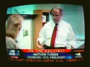
Greta Van Susteren of Fox News came to the office of GeoModel, Inc. to obtain information on ground penetrating radar (GPR). Greta Van Susteren interviewed Matthew Turner, GeoModel's ground penetrating radar expert who is a licensed professional geologist with over twenty years of GPR experience. GeoModel, Inc. gave a demonstration of the GPR equipment and the GPR images that can be obtained. Fox News' Greta Van Susteren was interested in information about the ability of ground penetrating … [Read more...]
CNN – GeoModel, Inc. Interview

Matthew Turner of GeoModel, Inc. was on the CNN Wolf Blitzer television news reports program. Matthew Turner was interviewed by a CNN national security correspondent at the GeoModel office. CNN was interested in the use of ground penetrating radar (GPR) to locate subsurface objects. Matthew Turner discussed the operating principles of ground penetrating radar and, using the GPR equipment, demonstrated the ability of ground penetrating radar to locate buried objects, such as utilities, deep … [Read more...]
Cemetery Preservation Work Continues
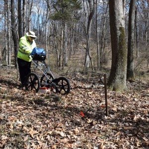
GeoModel, Inc.'s Matthew Turner conducted a ground penetrating radar (GPR) survey to help locate gravesites in an African-American graveyard in the woods across from the Leesburg Executive Airport, south of Leesburg, Virginia. … [Read more...]